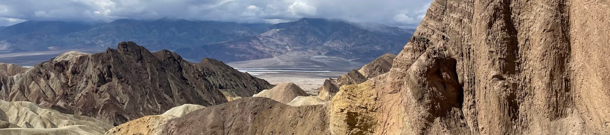
On Tuesday morning after enjoying more of the sculptures near Borrego Springs, we headed back to the southern portion of the park to an area called Fish Creek Wash which includes Sandstone Canyon at about the 14-mile mark in the wash. A geologically fascinating area where the geologic history spans over 200 million years. While it was all amazing, the sheer number of recent fossils (shells, stems, seeds, worms, burrows and small coral) deposited in shallow seas near the end of the last glaciation was staggering. Apparently, there are wooly mammoth and other recognizable critter fossils in the area also. We did not see them, but in our first foray up the road, we stayed pretty close to the track.
Just beyond where we turned west up the wash there is an active gypsum mine. US Gypsum has been actively working the mine since the 1920’s. The gypsum deposit is approximately 250 feet deep, and characteristics of the gypsum indicate that it was probably deposited by underwater thermal vents when this area was part of the Imperial Sea. Millions of years ago, the Imperial Sea existed as far north as the Coachella Valley which includes the Salton Sea and area north of there. From the south shore of the Salton Sea to Mexico, the area is designated as the Imperial Valley. Fossil remains of corals, mollusks and sand dollars indicate that the Imperial Sea existed before the Americas were joined at the Isthmus of Panama — a connection existed between the Caribbean Sea and the eastern tropical Pacific Ocean.
The road was very interesting and a fun drive. A bit washboarded (my watch recorded almost 30,000 steps in the 24-mile drive), but just more reason to add a small tire compressor to the on-board equipment so that we can depressurize the tires and smooth out the ride. Amazing canyons varying from wide area vistas to slot canyons. There is a primitive camping area up on a terrace above the canyon floor a few miles in that looked like a nice spot to spend a night. Most of the trail is on BLM land and there are a couple of areas that are closed off, but there were ample other camping spots available.
After a very nice lunch, we checked into the park headquarters and got the info on where the desert flowers were blooming. We headed to the suggested locations. The flowers were amazing! We had no trouble finding them and spent a fair amount of time enjoying them and taking photos. The photos of sculptures and flowers can be seen below.
On our way back to our accommodations we were distracted along the way when we saw large metal sculptures of mostly prehistoric animals, dinosaurs and even a serpent of some sort. These sculptures sit on public land. They were commissioned by a local resident and developer. A Perris, California artist named Ricardo Breceda created the 130 sculptures distributed around the Borrego Springs area. Our sculpture viewing slopped over into the trip to Sandstone Canyon shown in the next post.
A 2-day trip to Anza Borrego to do a little hiking and offroading, but mostly to see the desert flowers blooming. With the wet year, the bloom was forecast to be pretty spectacular, peaking around the second week of March.
After a two-hour drive from Taos Ct. we arrived at The Slot, one of the most popular hikes in Southern California. It isn’t a long hike (about 2.7 miles) and there is not a significant elevation change (298 feet). However, the beginning of the trail drops into a creek channel eroded in badlands type of formation that does get extremely narrow in spots. It then opens up into a comfortable stream channel that has cliffs on both sides. All was well until we had to climb out of the channel up onto the ridges above the stream. All 298 feet of the elevation that we lost going downstream was recovered in one relatively short, steep climb to the top of the bounding ridge. We survived and enjoyed our hike immensely.
We headed back north to Borrego Springs and hunted out a great little Mexican restaurant for a well earned lunch. The photos below are from the hike.
After stops in Mystic CT, and Newport RI and enjoying the foggy coast of Long Island Sound, we turned north to Gloucester, MA. We tried to make the drive as scenic as possible, but it is a struggle when you are working your way around Boston. We continued to count Tesla’s and Dunkin (Donuts). Turns out Massachusetts has more Tesla’s than we had seen on the previous road trip days. But donut shops were still winning by a margin of about 10 to 1.
When you drive into Gloucester and see the town, the architecture, the docks, the boats and the water you sort of expect to see everybody walking around in yellow cagoule and hoods looking like the Gorton’s fisherman. It definitely has a New England fishing port vibe. We found our way to the Hotel at Cape Ann Marina and settled in.
First order of business was getting together with cousins Laurie and Ann-Marie. Laurie (who I had not seen in about 10 years) has lived in Gloucester for many years (20+) and Ann-Marie (who we last saw in 2002) had opted to visit from her home in New Jersey while we were there. We had a very nice dinner and in general caught up with the last several years activities and family news.
Laurie and Ann-Marie are part of the Uncle Andy/Aunt Dottie side of the Hagar clan. Uncle Andy was the oldest of the four boys and according to lore had to keep my dad in line who apparently was something of challenge.
I think it is pretty clear who the troublemaker in this group is.
After a few after dinner cordials in our room, the clan dispersed, and we decided to meet the next morning for the tour de Gloucester.
Based on recommendations, we found a great breakfast spot. A small place with inside seating for only about 20 people. With a name like Mom’s Kitchen, it had to be good. We had breakfast there … twice. Second time, our server seated us with her mom. What a hoot!
After a hearty and delicious breakfast, we were off to meet Laurie and Ann-Marie for the tour. After only getting lost once, we found Laurie’s place. What a great location and great layout with room for a vegetable garden.
It was still a little rainy but that did not deter us. We made several stops in East Gloucester which is apparently the high rent area of town. We then went on to Rockport which is north of Gloucester where it turns out that love of hot dogs is apparently a Hagar weakness. While in Rockport, a painting spoke to Joni, and it became a companion for the rest of the trip. It is now on the wall in our little dining area.
Dogs all around!New Family Member
While in Rockport, we took the obligatory picture of the most photographed, painted, lithographed and decoupaged building in all of New England. It is pretty photogenic. I like the S&S Catalina 38 sailboat hiding just to the right of the building behind the blue hulled boat.
From Rockport we proceeded to the Paper House. Someone with significant time on their hands … maybe a retired geologist … built an entire house out of rolled up and folded newspaper including the furniture and as I recall the piano.
Next stop was Halibut Point State Park. This was a very interesting stop on Cape Ann. It was an active granite quarry on the coast with views worth photographing and even better, exciting geology. This is some of the oldest granite in the area, intruded as a magma during emplacement of exotic terranes during the breakup of the super continent Rodina… the one before Pangea. It was mined for almost 90 years. We also learned a bit about the origin and application of the word halibut. From middle English, hali or holy was because the fish was eaten on holidays and butt which means flat fish. At the park they described the reason that the park got its name had very little to do with fish. It seems that when the boats sailing south reached the tip of Cape Ann the Captain would call out “Haul-about” to reset the sails and navigate around the land mass and head toward Rockport Harbor. Thus, the name Haul-about Point was born. Over the years, the term, like so many in New England, was shortened and became Halibut.
From Haul-about point, Laurie and Ann-Marie took us to Maritime Gloucester where Laurie has been active for many years with the dory program and schooner activities. Very cool place. Based on being on a first name basis with most of the people we ran into, it seems that she has found a very worthwhile cause to support while having fun and getting some time on the water.
We enjoyed dinner at the restaurant at the hotel. Very tasty and good music. There was a blue moon (brightest and largest moon of the year) that evening, but it was not as clear as it could be, and our timing was not spot on. We did spend time staring at the moon from the dining porch which was quite scenic and relaxing.
The next morning, we headed north with some recommendations from the ladies on things to not miss in Acadia National Park area. More on that next blog posts.
Lots of photos in the show below. Some repeats from those above but it seemed that they fit in line with what I was writing about.
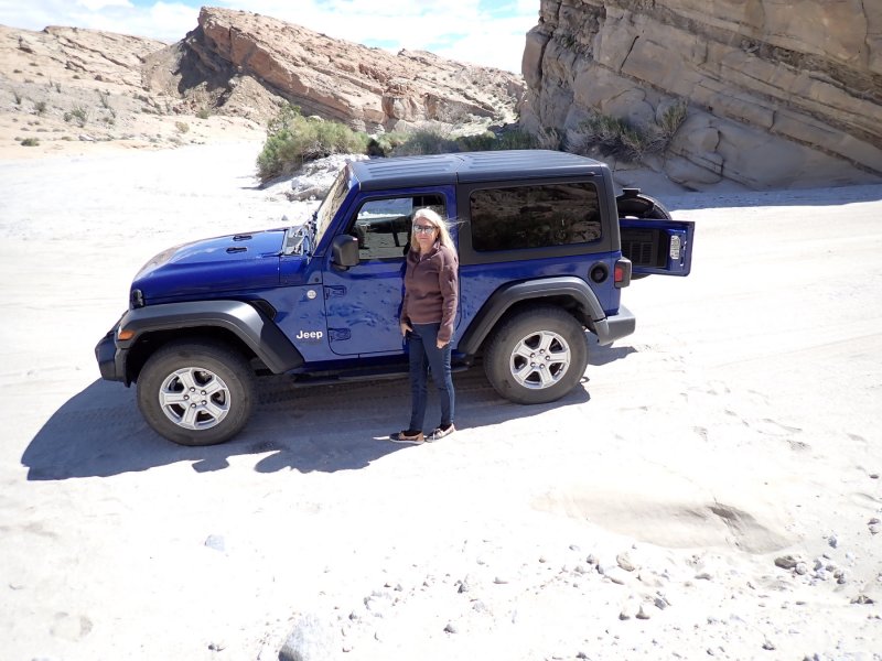
An exciting road trip with several planned stops. Kiara came along for the first few days and Joni rode with her in her car while I was learning to be at one with the new Jeep. We left early on a Thursday morning in the middle of a crazy wind and dust storm with occasional drizzle to add to the fun. Just west of Blythe we experienced a haboob on I-10 with complete invisibility in the dust storm… an adventure for sure. First stop other than gas was Sedona for a short, overnight stay with our friend Reylyn at an airbnb that she had set up and a visit with old friends Steve and Deni from E-Dock. There are more pics of the airbnb below but here is the kitchen and the hot tub (note Kiara’s stocking cap).
Move Slider for Full Photo
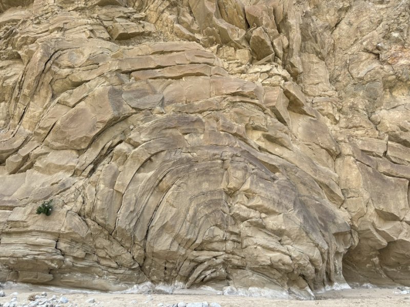
Sedona is another one of those locations that geology has created for the shear enjoyment of the masses (that’s my story and I’m sticking with it since I am one of the masses). The town sits at the base of the Mogollon Rim which is the boundary of between the Colorado Plateau to the north and the Basin and Range province to the south. Everything is uphill toward the Colorado Plateau and more or less downhill (with intervening ups) to the south. The most striking views of Sedona include cliffs of red to beige sandstones, siltstones and some other miscellaneous sedimentary rocks of the Schnebly Hill formation. While this formation is unique to the Sedona area, it is considered to be part of the Supai Group. The Supai was deposited about 275-270 million years ago (mya) on the Pangea supercontinent. Working our way up above the Supai is the Coconino Sandstone and above that, the Toroweap Formation. Particularly in the cliffs south of Sedona, there is evident cross bedding in these sandstones since the formations were deposited in a desert environment with windblown sand dunes being very common. For those that have been to the Grand Canyon, these formation names may ring a bell as they make up significant portions of the canyon walls.
The Supai to the south and southeast of Sedona is capped with volcanic rocks that originated from 3 million to 15 million years ago from the Mormon Mountain Volcanic Field which includes over 250 individual volcanic vents from a 1.000 square mile area south of Flagstaff, Arizona. One of the most impressive facts associated with this series of outcrops (at least to geologists) is that there is almost 240 million years of missing rocks between the sedimentary cliffs of the Sedona area and the volcanic cap rock on top of these cliffs.
The pictures below in the usual photo album view are from the Airbnb we stayed at and two short hikes that we took before we headed north out of town for Winslow, Arizona and the La Posada Hotel. Here is Kiara on the corner in Winslow and next to the flatbed ford.
Wowzers!!! Three adventures in a week and this one more of an unusual location for us! The flat and very low-lying Salton Sea area.
The Salton Sea is that big darn lake that has a higher salinity than the Dead Sea, that you see on maps of the low desert of California including the Coachella and Imperial Valleys in Riverside and Imperial County and the Lower Colorado River Basin. It’s difficult to realize how big of an area it covers until you actually see it. The current lake is about 15 miles wide and 35 miles long with a surface elevation of approximately 236 feet below sea level with a maximum depth of about 43 feet. That makes the bottom of the Salton Sea only 3 feet higher than the elevation of Badwater Basin in Death Valley, the lowest point in the US.
Location Map – Salton Sea, CA
To add to the story, the Salton Sea is landlocked in a closed drainage basin; it is in one of the most faulted areas of California; the San Andreas Fault ends at Bombay Beach on the northeast shore and if you are ever asked to bet where the next volcanic eruption in California will be, I would recommend you bet on the Salton Buttes area.
As far as the long-term history of the Salton Trough, the Gulf of California (Sea of Cortez) would extend as far north as Indio, 150 miles northwest of its current limits, were it not for the delta created by the Colorado River. Over three million years, through all of the Pleistocene Epoch, the Colorado River delta expanded until it cut off the northern part of the gulf. Since then, the Colorado River has alternated between emptying into the basin, creating a freshwater lake, and emptying into the gulf, leaving the lake to dry and turn to desert. Wave-cut shorelines at various elevations record a repeated cycle of filling and drying over hundreds of thousands of years. The most recent freshwater lake was Lake Cahuilla. It covered over 2,000 square miles of the basin, six times the area of the Salton Sea. It goes without saying, eventually, the delta will be destroyed, and the Gulf will creep northward until most of the Coachella Valley becomes ocean front property.
While there had been previous lakes in what is now known as the Salton Sea and beyond, the Salton Sea as we know it did not exist. Short story is that prior to 1900 it was dry land farmland. An irrigation canal was constructed, and the area now inundated as well as significantly beyond the Salton Sea flourished as irrigated farmland The history is somewhat convoluted and tied closely to development of the agriculture in the Imperial Valley. The irrigation canal constructed in 1900 became silted in and an engineer for the canal company/owner authorized construction of an uncontrolled breach in the Colorado Riverbank downstream of the obstruction. A wet year with well above average snow melt in 1905 caused the Colorado River to flood and for two years, the entire flow of the Colorado River was diverted into the Salton Sea. After significant intervention, the breach was closed in early 1907.
Since then, the history of the Salton Sea has been one of litigation, politicizing, lying, cheating, environmental degradation and resurgence, fortunes made and lost and general blundering. But what about those volcanos aka the Salton Buttes that we drove south to see.
The Salton Buttes are a group of relatively low relief volcanoes, on the southeast shore of the Salton Sea. They consist of 4-mile-long row of five lava domes, named Mullet Island (located offshore), North Red Hill, Obsidian Butte, Rock Hill and South Red Hill. They are closely associated with a geothermal field, and there is evidence of near surface (5,000 – 10,000 ft bgs) magma.
This is a relatively abbreviated discussion of the history of the Salton Buttes. The Salton Buttes lie within the Salton Trough, a tectonic depression formed by the San Andreas Fault and the San Jacinto Faults. The depression forms the northward extension of the Gulf of California and is separated from it by the Colorado River Delta. A number of geothermal and volcanic features are located in the area, which is a region of active seafloor spreading. There are several geothermal plants visible from the Salton Buttes area. Within the immediate vicinity of the Buttes, there are also mud volcanoes. Access to these is controlled as you never can tell what moronic prank the general public the public is going to do in their never-ending goal of achieving the elusive 5 minutes of fame.
The Salton Buttes formed within the last 10,000 years during the current Holocene epoch, mostly through relatively viscous flows of iron rich lavas, highly gas charged pumice and ash. Future eruptions are possible and likely depending on how long of a time is associated with the word likely.
The pictures below show a variety of views of the Rock Hill volcano, some longer distant views of the North and South Red Hill Volcanoes and a plethora of Obsidian Butte and the collecting of obsidian for the Taos Ct. pictures. The last group of photos is from Bombay Beach (the southern terminus of the San Andreas Fault) located on the which houses an eclectic collection of humanity in a small community that at one time was a thriving resort on the beautiful shores of the now somewhat stinky Salton Sea. There is a very fine bar and food stop called the Ski Inn in Bombay Beach where the burgers are fine, the beer is cold, the jukebox has great tunes from my generation and all of the walls and ceilings are covered with signed dollar bills from previous clients.
It has been an exciting week at Taos Court. Adventures have been piling up and getting accomplished at a dizzying rate. Joni had to work on a groundwater report for Northgate and I think she gets a little freaked out when I just sit and stare at her all day while she works. So … I soloed it to one of the 4 wd trips that is on the list on a cloudy but relatively warm day with very little wind at the JTNP.
The Geology Tour Road is a relatively easy 17.1-mile unpaved road that heads south through the park from the main east-west road (Park Blvd.). The small but powerful CMAX could have made the first 5-miles. After that we probably would have left the exhaust system on the road.
The blue line is the Geology Tour Road.
I’ve written about the geology of JTNP in other posts to the blog. Suffice to say that Park Blvd. is the most scenic single road in JTNP. It was routed so that folks driving through the park would have the best scenic views of vegetation, wildlife and geology, access to camping and picnicking and stunning camera vistas to take home. The tour road serves a different purpose. It is a tour through time and the geologic history of the park.
This was a reconnaissance trip. In the future, we will take the road and make focused stops with hikes to enjoy the vistas and the geologic history of the area of the park. There is in fact a more challenging jeep route that starts at the south end of the Geology tour road and crosses the Little San Bernardino Mountains ending up in the vicinity of Thousand Palms…. Hmmm.
An off-road/hiking trip primarily to retrieve more rocks for landscape enhancements at Taos Court. A great day at Painted Canyon! The trip started by following the two-track for about 1/2-mile. At that point a drainage to the northeast presented itself with some tracks. Continued for a couple of miles up the fairly wide and open drainage with numerous side drainages and my favorite, slot canyons for exploring.
Slot Canyon Entrance
This route primarily was through the Pleistocene Epoch (approx. 1 million years ago) Upper Palm Springs bedded sandstone and siltstone member. This unit was deposited in shallow lake environments with intermittent flooding bringing coarser grained material into the bedding. There is also indication that some of the bedding was located at the end of a larger alluvial fan which were and are common in this area.
QPubss flood deposits (Knife for scale)
Eventually (about 750,000 years ago), due to movement along the Painted Canyon Fault located southwest of this drainage, a significant portion of the Upper Palm Springs Member was cut off from extensive deposition experiencing localized deposition only.
The last series of photos from this trip show an area immediately adjacent to the San Andreas Fault at the front of the Painted Canyon entrance where the hills are composed of red fault gouge material due to multiple splays of the fault moving in this area. The hills are the result of compressive forces built up along the fault traces.
Looking south along the San Andreas Fault at front of entrance to Painted Canyon
All of the photos from this excursion are included below.
After a decadent dinner, great night’s sleep and breakfast at La Posada in Winslow, Arizona, we headed for Petrified Forest National Park (PFNP), one of the smaller, less traveled but most dog friendly national parks in the country. Like most of the area in eastern Arizona along I-40, it does not appear to be a likely spot for a national park. Joni had last visited the park a little over 50 years ago, so we were due. Kiara and Joni were in Kiara’s small, but powerful Honda Civic and I was becoming “at one” with the new jeep. We met up in the parking lot of the northern visitor center and carpooled in the Civic on our old folks NP pass.
The park north of I-40 is mostly the Painted Desert. Very colorful and picturesque, especially with the veneer of snow on the ground. As you loop around the northern portion of the park road and head south to the I-40 overpass, you cross the remnants of Route 66 which is commemorated with a front fender of what looks like an old Buick and a rusted-out Studebaker truck. As you tour the park south of I-40, you drive into the petrified wood part of the park nicely accented by the geologic formations of the Painted Desert.
The geology of the park is dominated by the Chinle Formation which was deposited in the mid to late Triassic Period between 238 and 201 million years ago. This was the time in the earth’s history when there was one big landmass (Pangea) and the area that is now the PFNP was a basin/lowland located near the equator. The area was very tropical, very wet and very warm with significant drainages and waterways. The trees that fell and were transported in the waterways were up to 9-feet in diameter and up to 200 feet tall. Sediment deposition in the streams and drainages was fast and furious and was supplemented with wind borne volcanic ash from volcanic activity west of the park. If the logs became fully buried in the sediments and ash in drainages before decomposition started, silica (quartz) from the volcanic ash would dissolve in groundwater and be carried into the logs replacing the cellular structure with quartz. This geologic period was also the dawn of dinosaurs and continued evolution of the progenitors of alligators and crocodiles. All of which have a rich fossil history displayed at the parks south entrance.
This was one of those stops where we spent about 7 hours exploring. During that time, we took 228 pictures or about 32 per hour. By far, most were of colorful petrified logs. Not to worry though! They have been culled down to the 77 pictures included below.
It has been a while since I have posted anything to the blog. Lots of excuses but it boils down to a case of the moth in the light bulb syndrome that I get afflicted with now and then. I plan on catching up with the road trip to New England and family visits in Gloucester, Massachusetts. For now, I’m just going to try to get started with the most recent hike/jeep trip. Yep, there is a new car in the garage to accompany the small but powerful (albeit; very low to the ground CMAX). A 2020 Jeep Wrangler Sport, 2-door in blue has joined the family. What better spot to take it for a relatively easy road with great hikes, great geology, and now great (but relatively mild) Painted Canyon Road just east of Mecca, California.
You may recall that there are a couple of previous hikes described in the blog for the Painted Canyon Trail. Some of the longest mile paces we have ever seen on hikes because we were taking geology pictures, touching rocks and just being geologists in a geologic wonderland. There are three major faults in the vicinity including the San Andreas Fault (SAF). The rocks in the area span almost 1-billion years of time. The vast majority of the exposed formations were actually deposited less than 6 million years ago along the margins of the Coachella Valley and Lake Cahuilla with major influence of the SAF and its friends to the east. There is a smattering of 100-million-year-old rock exposures, particularly along the Painted Canyon Fault.
The picture below is a geologic map taken from a paper by McNabb, et.al. (2017). The polygon on the map is about 8 miles both north-south and east-west. The nasty looking wiggly black lines that trend from the northwest to the southeast are the faults in the area. The road in follows the squiggly magenta section line that trend from southwest to northeast in the lower rectangle.
There is a lot of tortured rock in this small area.
The Little Painted Canyon trail more or less trends northwest from where the two magenta lines intersect. It is a jeep/truck trail (we parked and hiked it although it would have been a relatively easy drive) and is significantly different than the Painted Canyon trail in that there are numerous side drainages that intersect the trail itself rather than hang from the cliffs. Also, the canyon is not as steep sided along the Little Painted Canyon trail as on the Painted Canyon trail. All in all, a very pleasant hike as we did not have to watch our footing as much. We did not go to the end as we needed to get back to the ranch for sunset.
Pictures below include some shots at the Painted Canyon Fault and then follow our out and back hike along the trail from the parking area.