I am writing about this adventure today with a profound sense of loss but hoping that the therapy of putting the story of this adventure together helps me turn my sense of loss to one of joy in having been part of his life. One of my greatest friends who I have known for at least 37 years passed away last night suddenly in his sleep. He was an individual who craved, embraced, and practiced the adventure lifestyle. This adventure is an homage to Jeff, dedicated to his quest for adventures and his adventurous outlook on life.
I had thought that the May Joshua Tree trip would be the last one until the summer oven had passed. However, due to a lot of unusual circumstances; lower than normal June temperatures; Joni being involved with providing support to our former employer (Northgate); the availability of Kiara to join in the adventure and I suppose just wanting to get out and move about, Kiara and I made what I am pretty sure was the last pre-summer trip to Joshua Tree. It was a simple plan. A forty-five-minute drive to the park in Kiara’s small but powerful (with a massive trunk) Honda; a hike on the Wall Street Mill – Wonderland trail, overnight car camping at Ryan Campground and a shorter hike on day 2 along the Skull Rock Nature Trail with a subsequent picnic lunch and park exit at the Cottonwood gate on the south side of the park near I-10.
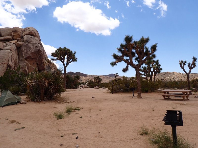
I procured a campground reservation at Ryan Campground Site 07. Joshua Tree was already operating on a summer schedule so there were areas that were closed including the entrance kiosk which was unmanned on arrival. We made a short stop at our campsite and set up our tents (to stake out our spot). The pictures include shots of the campground and Kiara created a video of the trip on her Facebook page that has some camping views.
Car Camping!
She had the larger of the tents and I had my little one-man tent that I last used sometime around 2000-2002 on a kayak camping trip to Santa Cruz Island. I was not sure how sleeping on the ground would work out for me. However, thanks to technology, I had a great ground pad that made it all possible.
Our Wall Street Mill and Wonderland Wash Loop hike ended up being 3.0-mile loop as we had to start from the Barker Dam parking lot. The hike to the mill was relatively easy although the trail was poorly marked and there were a lot of side trails to choose from. The phone GPS kept us on (or close to on) the trail. The mill was built by Bill Keys (see previous post) in the late 1800’s. It is a gold ore crushing mill that had two stamp mills and some outbuildings including a bunk house and of course out house. There had been a marker at the start of the trail placed by Bill Keys in 1943 after his release from San Quinten with the inscription “Here is where Worth Bagley bit the dust at the hand of W. F. Keys, May 11, 1943”.Of course, it had to be removed for preservation after being vandalized by despicable morons and is now memorialized by a national park marker.
The second part of the hike that wound through Wonderland Wash was a bit more challenging. The trail (or proposed trail) from the Mill to the actual Wash traverses a large, lower relief area of the Monzogranite of Indian Cove. This is a popular bouldering and rock-climbing area where there really was no specific trail but a lot of rock scrambling. The area has a little more moisture and soil available so there was a significant cactus bloom. I, of course, had an up close and personal encounter with at least one cactus as I hopped off a boulder a little clumsily (Kiara was much more fluid in her movements – youth) leaving numerous splines in my left leg. We eventually made it to the wash which was a very enjoyable, relatively flat, and wide trail, past the Wonderland Ranch ruins (pink building in photos) and back to the Barker Dam parking area.
We returned to our campsite, set out the chairs, grabbed the cooler and feed bag and had a very nice picnic lunch of normal goodies. I was tired from our hike and Kiara had been up to 2:00 AM the night before yukking it up with Joni so a quick nap after or late lunch seemed to be in order. A sunset dinner of pre-cooked lasagna warmed on the old Coleman emergency earthquake grill finished out the day. A very comfortable night in our nylon casitas, coffee/tea, egg bites and sausage for breakfast started day 2 of the adventure.
After breaking down camp we headed out to the entrance for a short cell coverage fix and then up to Keys Vista which provides a great view of the Coachella Valley. From there to the Skull Rock Trail which is a 1.7-mile loop that includes several national park markers describing the flora, fauna, and geology. The trail winds its way through the Monzogranite of White Tank, some very young stream outwash and some very young fan material. Of course, the star of the trip was the slightly alien looking Skull Rock that you can see in the pictures. On the trail back to the parking area, we stopped in a nice shady spot and Kiara took the opportunity to sketch a Yucca plant. So nice that all the girls did not inherit my lack of any known artistic talent!!
After Skull Rock we searched out a picnic spot. Kiara found a shady spot in the rocks on the road south toward the I-10 entrance and she whipped up some bagel, pastrami, and cheese sandwiches. A quick stop at the Cholla Cactus Garden wrapped up our JT5 trip.
I promised a little more geology of the park in the last blog so here goes. A lot of folks have trouble visualizing geologic time since we think more in terms of human lifetimes. For those of you who remember the big round classroom clocks in school that gained significant importance about 5-minutes before the school bell rang, consider that one full trip of the little hand around that clock is 12 hours. If we condense the 4.6 +/- billion years of geologic time scale into a 12 -hour clock here are some ideas of how long-ago things happened. In today’s geology installment we are going to be looking at rock formations in Joshua Tree NP that formed in the Proterozoic Period in the Precambrian Era which started about 2.3 billion years ago and ended about 541 million years ago. Thinking about our clock analogy, the Proterozoic started right after recess at around 10:57 AM and lasted until just after bedtime at about 9:10 PM. For comparison, the dinosaurs went extinct about 66 million years ago or around 11:39 PM deep into the Tonight Show. Humans did not show up until about 200,000 years ago or at about 1 to 2 seconds before midnight … the Times Square ball just hit the bottom.
The oldest rock outcrops in Joshua Tree are predominantly gneiss (Pinto Gneiss formation) and the Quartzite of Pinto Mountain. These are metamorphic rocks that formed in the Proterozoic. Keep in mind that metamorphic rocks have protolith rock associated with them (i.e. they were something else before they became metamorphic rocks).
So here you go — the seas came in and the seas went out. This description is extracted and modified from a great little book; Joshua Tree – The Complete Guide by James Kaiser. Way back in the deep dark past, when there may or may not have been even much of a primordial ooze, there were land masses on the earth. If we are to believe the “experts” the earth was probably significantly more dynamic back then between things hitting it, the moon being blasted off at some point earlier and also having an extra billion or so years to experience uplift and erosion. As eroded sediments washed off ancient continents into the ocean, thick sediment layers accumulated in the waters offshore. Over time, the bottom layers were compressed and formed sedimentary rock (think Grand Canyon not the inner gorge). Then, around one billion years ago, Earth’s continents collided to form a single supercontinent called Rodinia (the super continent before its more famous younger relative, Pangea). As the continents collided and smashed into one another, they crumpled (a geologic term for sure) along their edges to form vast mountain chains. Some of the previously formed offshore sedimentary rocks were caught up in these collisions, which generated extreme heat and pressure. Over thousands of years, this heat and pressure metamorphosized the sedimentary rock into gneiss (pronounced “nice”). Gneiss is characterized by obvious banding/layering of darker and lighter minerals in the rock. There are other metamorphic rocks of the same age in the park including quartzite and dolomite.
Then, around 800 million years ago—200 million years after the formation of Rodinia—Rodinia broke apart. North America drifted toward the equator, and Joshua Tree’s gneiss and other metamorphic rocks most likely became part of an offshore continental shelf covered with ocean that was largely lifeless. For the next 250 million years, the Joshua Tree region lay underwater. Then chapter 3 of the Joshua Tree geologic history that we can discern began around 335 million years ago, Earth’s continents came together again and formed another supercontinent called Pangaea. The Joshua Tree region lay just off the northwest coast of Pangaea, and additional offshore sediments accumulated on top of it. When Pangaea broke up about 200+/- million years ago (just before the dinosaur franchise appeared and as the Atlantic Ocean began to form), the North American Plate drifted west and collided with a vast (I love a good superlative) tectonic plate called the Pacific Plate, which underlies much of the present-day Pacific Ocean. The collision eventually pushed the Joshua Tree region up above water. It also generated intense heat and pressure that exposed the previously formed gneiss to a new round of metamorphism. The takeaway here is that the already tortured ancient gneiss and quartzite were subject to a second metamorphism; Joshua Tree NP rose from the deep bowels of the earth and then through the magic of erosion, faulting, and mountain building, we ended up with what we see today…. More on the glossed over Pangea geologic history in the next installment. The photo below shows the location of the outcrops in JTNP that are Proterozoic in age.
The colored areas within the park boundary on the map below show the distribution of Proterozoic rock outcrops throughout the park. There is a little license in this interpretation as it includes a few much younger areas that include Proterozoic rocks…. More on that in tectonics next trip.


